
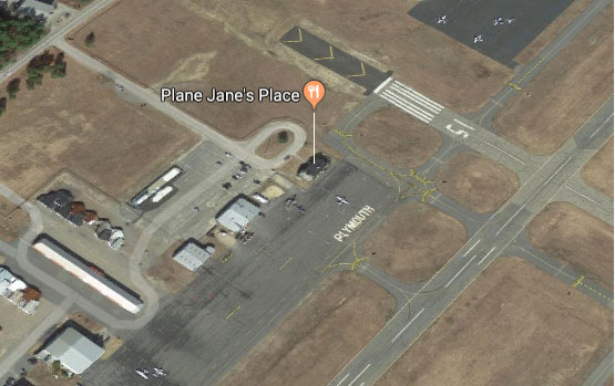
Fly in for Breakfast, Lunch or Dinner
FAA INFORMATION EFFECTIVE 30 JUNE 2011
Location
FAA Identifier: PYM
Lat/Long: 41-54-32.5000N / 070-43-43.6000W
41-54.541667N / 070-43.726667W
41.9090278 / -70.7287778
(estimated)
Elevation: 148 ft. / 45.1 m (surveyed)
Variation: 16W (1995)
From city: 4 miles SW of PLYMOUTH, MA
Time zone: UTC -4 (UTC -5 during Standard Time)
Zip code: 02360
Airport Operations
Airport use: Open to the public
Activation date: 03/1941
Sectional chart: NEW YORK
Control tower: no
ARTCC: BOSTON CENTER
FSS: BRIDGEPORT FLIGHT SERVICE STATION
NOTAMs facility: PYM (NOTAM-D service available)
Attendance: 0600-2200
Wind indicator: yes
Segmented circle: yes
Lights: DUSK-DAWN
ACTVT MIRL RYS 06/24; 15/33; MALSF RY 06 & REIL RY 24 – 122.900.
Beacon: white-green (lighted land airport)
Airport Communications
CTAF/UNICOM: 123.0
WX ASOS: 135.625 (508-746-8003)
CAPE APPROACH: 118.2
CAPE DEPARTURE: 118.2
CLEARANCE DELIVERY: 127.75
WX AWOS-3 at GHG (12 nm N): 120.0 (781-837-0555)
WX ASOS at TAN (13 nm W): 132.675 (508-824-5005)
WX ASOS at EWB (17 nm SW): PHONE 508-992-0195
APCH/DEP SVC PRVDD BY BOSTON ARTCC ON FREQS 128.75/290.3 (BARNSTABLE RCAG) WHEN CAPE APCH CTL CLSD.
Chamber of Commerce:
Hotel Info:
- Comfort Inn
(508) 746-2800 - Radison
(508) 747-4900 - John Carver Inn
(508) 746-7100 - Hilton Garden Inn
(508) 830-0200
Taxi Info:
- Patriot Taxi
(508) 747-1702 - Mayflower Taxi
(508) 746-8294